


SatFinder Lite - TV Satellites

คำอธิบายของSatFinder Lite - TV Satellites
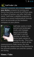
SatFinder Lite, โปรแกรมค้นหาดาวเทียม Android
รุ่น Lite เป็นรุ่น slimmed ลงของเต็ม SatFinder ซึ่งมีฟังก์ชันการทำงานเพิ่มเติมเช่นมุมมองเป้าหมายดาวเทียมและไม่มีโฆษณา
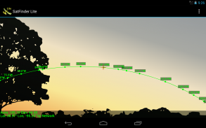
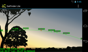
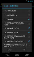
SatFinder เป็นเครื่องมือในการหาดาวเทียมทีวีและสอดคล้องจานดาวเทียม ใช้มุมมองความเป็นจริง Augmented กล้องของคุณจะเห็นและกำหนดเป้าหมายดาวเทียมในท้องฟ้า มันสามารถใช้ที่ใดก็ได้ในโลกตั้งแต่ทุกดาวเทียมโทรทัศน์ใหญ่อยู่ในฐานข้อมูล
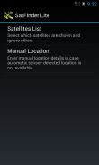
* คุณลักษณะใหม่: ความสามารถในการใส่เส้นรุ้งเส้นแวงที่ตั้งและรายละเอียดด้วยตนเองในกรณีที่สถานที่ไม่สามารถระบุได้โดยอัตโนมัติในกรณีที่ "ไม่มีการเชื่อมต่อ"
SatFinder ใช้เซ็นเซอร์โทรศัพท์ของคุณในการตรวจสอบสถานที่ตั้งทางกายภาพของคุณและคำนวณราบและระดับความสูงที่จำเป็นสำหรับเสาอากาศดาวเทียมของคุณไปที่ใบหน้า เนื่องจากการคำนวณตำแหน่งดาวเทียมขึ้นอยู่กับความถูกต้องของเซ็นเซอร์ของอุปกรณ์ที่อุปกรณ์ของคุณควรจะปรับโดยการเขย่าและการเคลื่อนย้ายไว้ในรูปที่ 8 แฟชั่นเมื่อ SatFinder ได้เริ่มต้น หากคุณมีปัญหาใด ๆ โปรดส่งอีเมลถึงการสนับสนุนของเรา @ support@droidwareuk.com
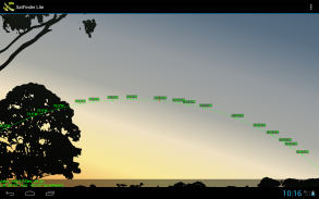
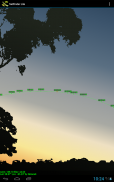
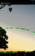
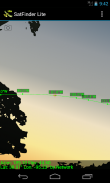
Augmented Reality View:
- ใช้กล้องของคุณสำหรับ Augmented ดูความเป็นจริงซึ่งวาดไอคอนดาวเทียมในสถานที่ที่พวกเขากำลังอยู่ในตำแหน่งในท้องฟ้า มันจะช่วยให้มุมมองที่สมจริงขึ้นไปบนฟ้าและมันจะช่วยให้แน่ใจว่ามีสายของสายตา (LOS) ที่กล่าวคือไม่มีอุปสรรคเช่นกิ่งไม้หรือท็อปส์ซูบ้านระหว่างจานดาวเทียมและเครื่องรับสัญญาณดาวเทียมของตัวเอง
- หน้าจอสัมผัสจะใช้หน้าจอในมุมมองของความเป็นจริง Augmented
- หยิกเพื่อซูมดาวเทียมทั้งในและนอก แตะสองครั้งเพื่อรีเซ็ต
เป้าหมายมุมมองดาวเทียม (ในรุ่นเต็มเท่านั้น):
- ใช้มุมมองดาวเทียมเป้าหมายที่จะหาหรือ "ล็อค" ดาวเทียมโดยเฉพาะอย่างยิ่ง ลูกศรทิศทางเพียงแค่แนะนำคุณไปยังตำแหน่งดาวเทียมที่ต้องการ
SatFinder Lite - TV Satellites--เวอร์ชั่น3.0.2
(17-10-2023)
SatFinder Lite - TV Satellites - ข้อมูล APK
เวอร์ชั่น APK: 3.0.2แพ็คเกจ: com.ftpcafe.satfinder.liteเวอร์ชั่นล่าสุดของSatFinder Lite - TV Satellites
เวอร์ชั่นอื่น


แอปในประเภทเดียวกัน


